
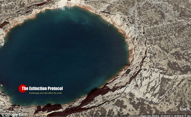
July 2016 – TEXAS – Satellite radar images reveal ground movement of infamous sinkholes near Wink, Texas; suggest the two existing holes are expanding, and new ones are forming as nearby subsidence occurs at an alarming rate. Residents of Wink and neighboring Kermit have grown accustomed to the two giant sinkholes that sit between their small West Texas towns. But now radar images taken of the sinkholes by an orbiting space satellite reveal big changes may be on the horizon.
A new study by geophysicists at Southern Methodist University, Dallas, finds the massive sinkholes are unstable, with the ground around them subsiding, suggesting the holes could pose a bigger hazard sometime in the future. The two sinkholes—about a mile apart—appear to be expanding. Additionally, areas around the existing sinkholes are unstable, with large areas of subsidence detected via satellite radar remote sensing.
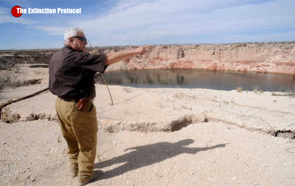
That leaves the possibility that new sinkholes, or one giant sinkhole, may form, said geophysicists and study co-authors Zhong Lu, professor, Shuler-Foscue Chair, and Jin-Woo Kim research scientist, in the Roy M. Huffington Department of Earth Sciences at SMU. “This area is heavily populated with oil and gas production equipment and installations, hazardous liquid pipelines, as well as two communities. The intrusion of freshwater to underground can dissolve the interbedded salt layers and accelerate the sinkhole collapse,” said Kim, who leads the SMU geophysical team reporting the findings. “A collapse could be catastrophic. Following our study, we are collecting more high-resolution satellite data over the sinkholes and neighboring regions to monitor further development and collapse.”
Lu and Kim reported the findings in the scientific journal Remote Sensing, in the article “Ongoing deformation of sinkholes in Wink, Texas, observed by time-series Sentinel-1A SAR Interferometry.” The research was supported by the U.S. Geological Survey Land Remote Sensing Program, the NASA Earth Surface & Interior Program, and the Shuler-Foscue Endowment at Southern Methodist University. The sinkholes were originally caused by the area’s prolific oil and gas extraction, which peaked from 1926 to 1964. Wink Sink No. 1, near the Hendricks oil well 10-A, opened in 1980. Wink Sink No. 2, near Gulf WS-8 supply well, opened 22 years later in 2002.
It appears the area’s unstable ground now is linked to changing groundwater levels and dissolving minerals, say the scientists. A deep-seated salt bed underlies the area, part of the massive oil-rich Permian Basin of West Texas and southeastern New Mexico. With the new data, the SMU geophysicists found a high correlation between groundwater level in the underlying Ogallala Aquifer and further sinking of the surface area during the summer months, influenced by successive roof failures in underlying cavities.
Satellite images and groundwater records indicate that when groundwater levels rise, the ground lifts. But the presence of that same groundwater then speeds the dissolving of the underground salt, which then causes the ground surface to subside. –Physics


In The near of that thinkwhole was Phil Snyder who went down of 10,000 miles together with a green barrat man and he recognised a underground world and he was injured ba a reptilian grey man by a laser weapen he got to the surface without some fingers and he told that happening in a video , you can see by youTube
LikeLike
What about the quarter size hole in the sun.sounds like niburi making the sun into a dwarf soon
On Saturday, July 16, 2016, The Extinction Protocol wrote:
> The Extinction Protocol posted: ” July 2016 – TEXAS – Satellite radar > images reveal ground movement of infamous sinkholes near Wink, Texas; > suggest the two existing holes are expanding, and new ones are forming as > nearby subsidence occurs at an alarming rate. Residents of Wink and neigh” >
LikeLike
you mean this one?
http://www.news.com.au/technology/science/space/nasa-is-monitoring-an-enormous-dark-region-spreading-across-the-surface-of-the-sun/news-story/09ee8292bfb45461d1f33773a06d303b
http://cdn.newsapi.com.au/image/v1/b14a5ee3404e5366a91e04882615b642
“nothing to worry about”
…awfully glad we can trust NASA on this, eh?
LikeLike