
June 2016 – SIKESTON, Missouri – It is well known that California and most of the west coast of the USA are thought to be long overdue magnitude 7 or stronger earthquakes. News there has been significant movement along the 800-mile San Andreas Fault in the Sunshine State and an emergency drill of how to deal with a devastating tsunami along the length of the west coast, have kept both impending natural disasters in the headlines across the globe.
But it has largely been forgotten that another potential disaster is lurking within the ground in Missouri. The 150-mile long New Madrid Seismic Zone in New Madrid, Missouri, is the source of the concern, and is also thought to be overdue for a massive tremor, which would impact seven states – Illinois, Indiana, Missouri, Arkansas, Kentucky, Tennessee and Mississippi. It has not seen significant earthquakes for more than 200 years.
In the winter of 1811 and 1812 there were three earthquakes of magnitude 7 – as high as 7.7 – and a series of aftershocks across the American Midwest. The results were catastrophic, with the course of the Mississippi being diverted, chasms ripping open, and volcanoes of sand and water bursting through the ground. The Federal Emergency Management Agency (FEMA) warned in 1999 there were four natural disasters which threatened the states.
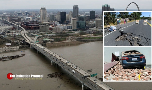
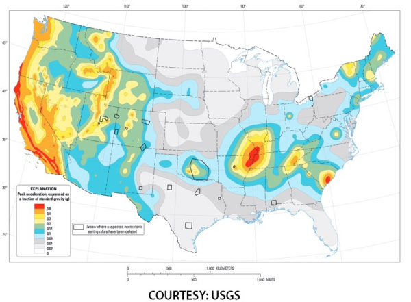
They included major hurricanes hitting Miami and New Orleans, which has recently been rocked by Katrina, and megaquakes hitting Los Angeles, and the central USA. The US Geological Survey (USGS) has a map of the country which includes a giant pink warning area over the central states. Each year there are hundreds of small tremors in the New Madrid Seismic Zone, including a 3.5 magnitude quake last month, which many saw as a precursor. The USGS even raised the threat level for 2016 after this increase in activity. Although the risk to these areas is less trumpeted than California and the west coast, $260million was spent on seismic strengthening of the I-40 bridge over the Mississippi into Memphis.
It is hoped the crossing, which towers over the river, could now withstand the anticipated shocks. Memphis state officials also reduced the main hospital by nine floors to limit the risk of collapse at a cost of $64m. The Mid-America Earthquake Center at the University of Illinois released a report in 2009, which suggested the effects of a force seven or stronger quake from the fault line. Amr Elnashai, the study’s lead author, wrote “All hell will break loose.”
The predicted scenario saw close to 715,000 buildings, including 130 hospitals, and 3,500 bridges damaged. Deaths and injuries were estimated at 86,000 with a combined loss of $300billion. The Central US Earthquake Consortium (CUSEC) is based next to Memphis Airport. James Wilkinson, its director, fears the Mississippi would be released from an engineered prison of levees, causing maximum damage. He told The Atlantic: “The thing that, to me, makes the river scary is how much industry we have along it: there’s power plants, there’s chemical plants, there’s ports. “And the river might change course altogether.
“I mean if we’re at flood stage, it’s kind of the worst-of-the-worst case scenario. “So if the levees are already jeopardised either by overtopping or saturation, where the water’s been there for quite a while, and then you get a shake to it? “You know, the river’s just gonna take the path of least resistance. And who knows whether that’s right through these communities.
“I doubt it’s going to stay in the channel it’s in. The Army Corps of Engineers battles that on a daily basis but the river’s already trying to change course. “They keep it somewhat channeled, but in a massive earthquake we could lose a good part of Western Kentucky, we could lose a good part of Arkansas or southern Missouri.”
He is convinced it is only a matter of time. He said: “We’ve had earthquakes, we’ve had damage, but nothing like what we’ve seen in other parts of the world. So the clock’s ticking.” But not all seismologists agree. Seth Stein, based in Evanston, Illinois, has researched the fault line for 30 years, and told The Atlantic the warnings were “dangerous nonsense.” He set up GPS receivers along the fault line and found the land was moving two millimeters a year, if at all, meaning there is next to no strain within it. He said: “Basically the way to think about the lithosphere – and it’s easy when you live in Chicago – is, imagine you have big chunks of ice floating around on the lake, and those things are sliding by each other.
So those are the plate boundary earthquakes, like in California. “But then within those big ice sheets you have small cracks. And there are very small motions within them. That’s how the big pieces stay together.” He claims Stein any recorded new rumblings are still the aftershocks of the 1811-1812 events. He added: “Every time there’s a magnitude 4 people like CUSEC are claiming giant earthquake’s on the way. And you think about this, and you look into the rock physics and it says no, it’s the opposite. Those are aftershocks.” –Express


It is possible that such events could occur within the nation that would take us out of the world picture and significantly reduce our influence as a world leader.
LikeLike
https://sentinelblog.com/2016/06/25/the-elite-dont-want-you-to-know-god-is-real-heres-the-proof-youtube/
LikeLike
I thought FEMA also rated the Cascadia Fault and the Yellowstone super volcano as major threats also. What effects do these seismic threats have on each other? Can one trigger another, they are not that far apart.
LikeLike
Um.. California is the “Golden State.” The “Sunshine State” is Florida.
LikeLike
Seth Stein’s (warning) message:
Nothing to worry about from UNDERGROUND…
LikeLike
“There is a fault line where there is no fault line.” Holy Spirit 2009. Saw a line on a US map stretching from Texas to NY. Another gentleman on youtube, followed fracking and minor quakes along that same line.
LikeLike
The San Andreas fault is in California. The “Sunshine State” is Florida.
LikeLike
i like that, edward. going to ponder it today 🙂
LikeLike