

June 2015 – CHILE – Haydee Pereira should be tired by this time of year serving clients at the Valle Nevado ski resort near Santiago. As it is, she has a lot of time to contemplate the mountains out the window — and the absence of snow. With 15 years experience working as a waitress at the resort, Pereira can’t remember the last time the slopes were this barren by mid-June. The only snow to be seen is the fake variety, put down last week for a photo shoot. “In all my years here, the snow has never taken so long to arrive or the season so long to start,” Haydee said as she stood in the resort’s deserted restaurant. Santiago, which sits below the ski resorts, has seen just 1.2 centimeters of rain this year, 86% less than normal, and there is none forecast for at least another seven days. The situation gets more complicated for Valle Nevado and the other ski resorts in the Andes mountains by the Chilean capital in a week or so, when package tours start to arrive from places such as Brazil.
People began skiing toward the end of May last year, with the resort officially opening June 14. This year there isn’t so much a shortage of snow, as a complete absence. For now, Pereira is serving the few Brazilians, Mexicans and Colombians that come up to see the mountains in between games of the Copa America soccer tournament. They are rewarded with a view of the smog lying over the city below, pollution that has been able to build up due to the lack of rain. It shouldn’t be this way. According to Chile’s meteorological service, the Pacific coast of South America is experiencing a mild El Nino effect, the climatic condition that typically brings heavy rainfall with it. Since 1968, 44 percent of the time the ski season has officially started after June 25, while it has been after July 1 in 25 percent of the years, according to Sotomayor. Central Chile has a climate similar to that in southern California — and a similar drought that has now lasted eight years. The water shortage forced the Lake Tahoe area ski resorts in California to close early this year.
It is getting harder for ski enthusiasts such as Stefanie Schultz, a 23-year-old graduate from the University of Oregon, to find snow. This pattern is happening everywhere in the world, not just in Chile,” Schultz said. “Every year, annual snowfall declines. This year ski resorts had to close early and Utah, Wyoming and Colorado also saw huge decreases in annual snowfall.” This season rivalled 1976-77 and 1980-81 as the lowest North American snowfall season on record, with most California and Pacific Northwest areas receiving less than half normal snowfall, according to bestsnow.net. Schultz is giving up and booking her return flight from Chile for July, a month earlier than she originally planned. “I will never forget that on July 5 two years ago, there was a huge snow storm, when there was already a lot of snow,” Schultz said. “At this rate, even if there is a huge storm like that, Valle Nevado won’t have enough snow to open many of the areas I skied that season.” –Skift
Glaciers melting at record pace on Mexico’s tallest volcano
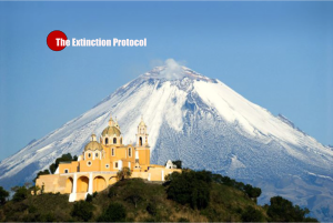
 As a result of warming temperatures, Mexico’s tallest volcano, Pico de Orizaba, is performing an all-natural striptease, the ice patches near its summit melting away to bare rock. The same process is taking place in the permafrost of Russia, the ice fields of the Yukon and the glaciers of New Zealand. And as the once-frozen world emerges from slumber, it’s yielding relics, debris — and corpses — that have been hidden for decades, even millennia. The thaw has unnerved archaeologists, given hope to relatives of lost mountain climbers and solved the mysteries of old plane crashes. What emerges is not always apparent — or even pleasant. That pungent smell? It’s a massive deposit of caribou dung in the Yukon that had been frozen for thousands of years, and now is decomposing in the air, its sharp odor unlocked. Pico de Orizaba towers above all other mountains in Mexico at 18,491 feet. It is the third-highest peak in North America, after Mount McKinley in Alaska and Mount Logan in Canada’s Yukon Territory. A challenging dormant volcano, Orizaba is a training ground for those interested in high-altitude climbing. For a handful of climbers, it has been their last peak. They’ve been buried by avalanches or swallowed by crevasses. Now, the mountain is spitting back their bodies. Late in February, a climbing party circled the jagged crater atop Orizaba. “One of them slipped, and they later said he skidded down and came to a stop. When he got up, he saw a head poking out of the snow,” said Hilario Aguilar Aguilar, a veteran climber
It was a mummified climber, a member of a Mexican expedition hit by an avalanche on Nov. 2, 1959. Some climbers fell near the Chimicheco Ridge, their bodies frozen in an icy time machine, only to re-emerge 56 years later. Hearing of the macabre discovery, prosecutors dispatched Aguilar and other climbers March 4 to document the scene of death. “Upon clearing away some snow so that I could take some photographs, I saw another hand. Suddenly, there were one, two, three hands. It didn’t seem possible. Digging a little more, we discovered that there was another body,” Aguilar said. The natural fiber rope connecting the two bodies had disintegrated to little more than a stain in the ice, he added. Aguilar said one of the mummified climbers appeared to be wearing remnants of a red sweater.
“I tried to bring a piece as a sample, for evidence, but it turned to dust when I touched it,” he said, adding that the mummified bodies are unlikely to be retrieved from the mountain until weather clears, perhaps in November. Then word came of another body, this one at an oxygen-deprived elevation of about 16,900 feet on another side of the crater. Aguilar and his crew went up June 4 and brought the body down on a metal gurney, dragging it down a steep slope. Wearing a suit inappropriate for a freezing clime, the victim may have been thrown from a small plane that crashed on Orizaba in 1999, although his identity is not yet known. Elsewhere around the world, explorers and scientists are stumbling upon mountainside plane wrecks, finding mummified Incan children, and discovering a frozen graveyard of ancient marine reptiles once hidden under a Chilean glacier.
Archaeologists are turning into unlikely beneficiaries of a warmer Earth, and several have started a new publication: the Journal of Glacial Archaeology. Its editor, E. James Dixon, an anthropologist at the University of New Mexico, frets about the phenomenon of ancient ice melting after thousands of years. “For every discovery that is made, there are thousands coming out of the ice and are decomposing very rapidly,” Dixon said. “In the ice, some of the most delicate artifacts are preserved. We’ve found baskets, arrow shafts with the feathers intact and arrowheads and lashings perfectly preserved.” Once the ice melts and the artifacts are exposed, they decay quickly. –The Bulletin
Solar output plunging to levels not seen in centuries – mini “Ice Age”


Welcome to El nino. It’s weather, not climate, as the alarmists like to say whenever it’s unusually cold.
LikeLike
the Glaciers melt, the Mountains are giving up their dead
sorta puts a new twist on the Scripture that tells of the Oceans giving up their dead…
here’s a 74 pic photo essay of many of the world’s glaciers, vintage photos followed by recent
the loss is not subtle.
http://www.weather.com/science/environment/news/glaciers-then-and-now
LikeLiked by 1 person
Stefanie should have stayed in the US.
http://ski.curbed.com/archives/2015/02/the-east-coast-is-having-the-best-winter-everfor-skiers.php
LikeLike
1976 – 1977 and 1980 – 1981 winters mentioned in this blog as very little snow… yes, probably so for the western mountains but how about the rest. 1980 -1981 was the COLDEST winter ever experienced in my life in New Jersey and I remember visiting Michigan late one January that was either 1976 or 1977 and Grand rapids had measurable snow every day that month.. a record at the time they said and there was a solid two feet of snow [ at least ] on the ground.
I do want to make a statement regarding the second half of the blog… High level atmospheric temperatures and pressures are the same as they have been but the warming that is happening is more insidious. the ground is warming. Ever notice after a big snow fall that even though temperatures stay below freezing for days after the storm that the snow continues to melt? There are two main factors. One; the air is dry and is able to wick a little of the moisture from the snow and two; the warmth of the ground enhances snow melt.[ from the bottom of the snow pack] Even more so when the snow is deep because the snow itself insulates the snow on the ground surface from the subfreezing temperatures in the atmosphere.
The core of the Earth is expanding it’s heat to the surface but that heat is hidden under the snow until it melts the snow. If a drought occurs the evaporation and melting happens more completely and quickly. That I believe is what is happening.
LikeLike
Joseph, i think you have answered a question i’ve been wondering, about whether the odd temperature split consistently seen across North America was something that ever used to happen… those first 2 winters you named were way before the constant sky trails began, that would seem to imply te split is at least in part a natural phenomenon. but, i’ll bet it’s still something our good ptbes work hard to enhance, as it certainly serves to keep a high level of debate & confusion going among americans as to whether climate change really exists.
LikeLike
Hi Yellow Bird! Yes, for all of my 58 years here the USA has had this split in the jet stream. When the western states would be warm the eastern states would be cold and reciprocally as well. The condensation trails you mention.. [ some call them chem trails ] have been along since the days airplanes first started flying into the stratosphere. It is simply the tiny amounts of water vapor in the burning fuel that saturates the cold air at those levels. When the stratosphere is very dry they will not appear but when moisture starts rising into the stratosphere from advancing moist air the contrails will form. Sometimes the contrails will seem to form in clear air when that cold air is very close to being saturated but not quite enough to form clouds yet. This is why it often seems to rain or snow within a day or two of seeing a large increase of contrails forming in the sky.
As for the line of thunderstorms that blasted through here the other night I am not sure if there were any official tornado measurements though I heard a couple of cars blew over in a mall parking lot about a dozen miles from here. The energy was released over a long squall line so no one cell got super powerful but many places received heavy wind and rain. Many people without power but we were ok here. Winds here I would say were over 50 m.p.h. at times.
The main cause for this squall was a large rising of air into the higher regions north and then it quickly snapped back south sending a large swath of dry air over the tropical air we had and BANG!
LikeLike
alvin, did you see the crazy super storms hitting Atlantic Seaboard yesterday??
completely nuts!
http://thevane.gawker.com/800-000-power-outages-reported-after-fierce-storms-blas-1713519831
“A line of intense thunderstorms rolled through the I-95 corridor this evening during the height of rush hour, stranding commuters, tearing down trees and power lines, damaging buildings, and even injuring a few people. After the rain wound down, more than 800,000 customers from D.C. to New Jersey were without power.”
http://www.weather.com/news/news/severe-weather-slams-northeast-june-23
more than 400,000 still without power today, across several states from MD to NJ
pix + a short newsclip offer a good visual.
some other online clips show ping-pong ball sized hailstones dropping
this is the same severe storm system that was responsible for more than a dozen tornados in the Midwest States on Monday. That same Midwest area is forecast to have another big storm come through today (Wednesday)
http://www.weather.com/storms/severe/news/high-plains-midwest-storms
LikeLike
No. Thx
LikeLike
Well I don’t know where the girl was looking because several rocky mountain ski areas had enough snow and cold to stay open till mid june!
LikeLike
wasn’t a good year for Mount Hood in Oregon
http://www.onthesnow.com/oregon/mt-hood-meadows/historical-snowfall.html?&y=2015
LikeLike
more major storms are being predicted for the NE states… hey Joseph, maybe you’ll want to post an update on what’s happening over there?
meanwhile, in the West & NW:

http://droughtmonitor.unl.edu/
i can’t remember when it’s ever been this extremely dry across so much of the West Coast at once
this weekend’s forecast is solidly 100+ across most of the western region, that’s 20+ degrees OVER average. then a few days “reprieve”- temps down to the low 90s but Dry T-storms scattered across NCa, OR & WA = severe potential for Lightning Wildfires.
Then, for most of the NW, forecasting is back up to 100-105 for several more days before promising to drop to the 90s again.
The entire 10-day forecast reads 10-20 degrees higher than average for most of the NW, SW, and a large part of Mexico… and that’s what’s so weird about it >> The national maps look like mid-August, not the tail end of JUNE.
http://www.weather.com/maps/forecast
this could really be a summer for everyone to remember
LikeLike
Hi Yellow Bird.. as you have asked for an update on conditions here. There are still thousands upon thousands of homes without power since last week’s major squall line went through. Another round of heavy rains on Saturday but no severe weather. While we got near two inches of rain here nearby northern Delaware got well over two inches of rain and around Atlantic City got 4 or more inches. parts of our region still have large trees sprawled out on the ground waiting to be removed. We have gotten over 7 inches of rain so far this month near Philadelphia Pa. but well over 10 inches of rain in Delaware and New Jersey shore points for June. More to arrive soon. Fortunately our soil type is deep and can hold a large amount of rain but over development fills our waterways too quickly. Hope the rest of you out there are faring well.
LikeLike