

-
Recent Posts
- 2020 Bizarre Weather: Could two hurricanes collide? Here’s what may happen if Laura and Marco meet up in the Gulf
- 2020 Bizarre Weather: Six waterspouts filmed swirling at once in Gulf of Mexico
- Space Watch: Asteroid predicted to pass close to Earth the day before the presidential election
- On Aug 16, a car-sized asteroid flew within 2,000 miles of Earth, the closest ever recorded, and NASA missed it
- 500 Wildfires Raging: Three California wildfires now rank among largest in state’s history, and they are still growing
Facebook
Donate – Support the site

-
Join 12K other subscribers
EP: Live Twitter Feed
Tweets by ExtinctionpArchives
- August 2020
- July 2020
- June 2020
- May 2020
- April 2020
- March 2020
- February 2020
- February 2017
- November 2016
- October 2016
- September 2016
- August 2016
- July 2016
- June 2016
- May 2016
- April 2016
- February 2016
- January 2016
- December 2015
- November 2015
- October 2015
- September 2015
- August 2015
- July 2015
- June 2015
- May 2015
- April 2015
- March 2015
- February 2015
- January 2015
- November 2014
- October 2014
- September 2014
- August 2014
- July 2014
- June 2014
- May 2014
- April 2014
- March 2014
- February 2014
- January 2014
- December 2013
- November 2013
- October 2013
- September 2013
- August 2013
- July 2013
- June 2013
- May 2013
- April 2013
- March 2013
- February 2013
- January 2013
- December 2012
- November 2012
- October 2012
- September 2012
- August 2012
- July 2012
- June 2012
- May 2012
- April 2012
- March 2012
- February 2012
- January 2012
- December 2011
- November 2011
- October 2011
- September 2011
- August 2011
- July 2011
- June 2011
- May 2011
- April 2011
- March 2011
- February 2011
- January 2011
- December 2010
Categories
- * Publisher Coupon Discount
- 1 Submit story
- 11:11 signature encoded
- 2012
- Acquatic Ecosystem crash
- Animal Extinction
- Apostasy
- Avalanche
- Black hole or supernova
- Black Swan Event
- Blizzard
- Breaking News Event
- Catastrophic Insurance losses mount
- Celebrities and the Apocalypse
- Chemical explosion
- Chemical Pollution
- Civilizations unraveling
- Climate unraveling
- Cloudburst storms with flashflooding
- Coal Seam Fire
- Comets
- Commentary
- Cosmic and Gamma Ray emissions
- Cracks
- Crowd Control technology
- Cryometeor
- Cyber Warfare
- Cyclone or Hurricane
- Dark Ages
- Deep Focus earthquake
- Deluge from torrential rains
- Derecho storm
- Derecho storm system
- Desertification
- Disappearing Lakes
- Disaster-related suicides
- Disease outbreak
- Dormant fault activation
- Dream Portal TEP
- Drought
- Drumbeat of War
- Dust Storm
- Earth Changes
- Earth Watch
- Earth's core dynamics
- Earthquake Omens?
- Eclipse
- Ecology overturn
- Economic upheaval, social unrest, terrorism
- Ecoystem crisis due to population boom
- Editor's note to readers – policy
- El Nino Effect
- Electric power disruption & grid failure
- Electronic Surveillence
- Emerging disease threat
- Environmental Threat
- Erratic Jet Stream
- Ethnic or religious strife
- Extinction Protocol Exclusive Editorial
- Extinction Threat
- Extreme Weather Event
- Famine Threat
- Financial System Collapse
- Fireballs
- Fireballs, Meteor or Asteroid
- Flooding
- Food chain unraveling
- Forecast book quotation
- Fracking quake suspected
- Frost Quakes
- Fungus outbreak
- Future coding
- Futuristic tech trends
- Gale-force winds and gusts
- Geomagnetic Storm Alert
- Geyser eruption
- Giant Earth Crack
- Glacial fracture
- Glacial Melt
- Global Debt Bomb
- Ground inflation
- Hailstorm
- Harmonic tremor swarm
- Hazardous chemical exposure
- Health guideliness issued
- Heatwave
- Helium Seepage
- High-risk potential hazard zone
- Hum noise
- Human behavioral change after disaster
- Human Migration
- Ice Storm
- Infrastructure collapse
- Invasive species threat
- Islands sinking
- Lack of snow
- Land fissures
- Land fissures, cracks, sinkholes
- Landslide & geological deformation
- Lava flow
- Lightning storm
- Limnic overturn
- Lithosphere collapse & fisssure
- Lurid acts of violence increasing
- Magma Plume activity
- Magnetic pole migration
- Marine animal strandings
- Martial Law
- Mass animal deaths
- Meteor or Asteroid
- Methane Seepage
- Monthly lead post
- Mud volcano
- Mudslide
- Mystery Boom & Shaking
- Natural gas explosion
- New Book
- New land rises from sea
- New virus reported
- New volcanic activity
- New weapons of war
- New World Order -Dystopia- War
- Nuclear plant crisis
- Ocean overturn
- Ozone Hole
- Pack Animal Aggression
- Pest Explosions
- Pestilence Watch
- Planetary discovery
- Planetary Tremor Event
- Polar Vortex
- Poleshift risks
- Pollution and Waste
- Potential Earthchange hotspot
- Prophecies referenced
- Quarantine
- Radiation leak or contamination
- Rare snowfall
- Reality Check
- Record Cold temperatures
- Record high temperatures
- Record rainfall
- Record snowfall
- Red Tide
- Resource war
- Rising tension between nations
- Rumors of War
- Scientific blunders
- Seismic tremors
- Signs of Magnetic Field weakening
- sinkholes
- Social unrest
- Solar Event
- Space Watch
- Strange high tides & freak waves
- Strange unexplained noises
- Subglacial flood event
- Submarine volcanic eruption
- Submarine Volcano
- Supermoon
- Supervolcano News
- Tectonic plate movement
- Time – Event Acceleration
- Time Portals
- Tornado Outbreak
- Tsunami
- Unknown phenomena in the sky
- Unprecedented Flooding
- Unseasonable Weather Event
- Unsolved Mystery
- Unusual hail storm
- Unusual solar behavior
- Ususual animal behavior for disaster
- Volcanic Ash
- Volcanic Eruption
- Volcanic gas emissions
- Volcano unrest
- Volcano Watch
- Water Crisis – Conflict
- Wildfires
Books by the Author
News website
Support
Youtube Channel


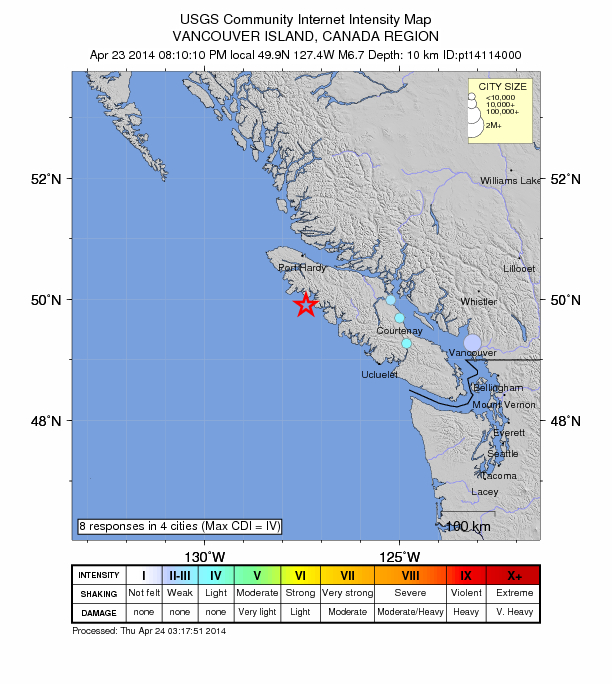
Live in Courtenay, B.C, felt the earthquake here it was only a slight rolling movement. My brother lives in Port Hardy and told me the walls of his house moved 1-2 inches but no damage.
LikeLike
I was just looking at the map today and thinking that it’s fairly quiet again. That’ll teach me to think.
I came across this article the other day. I know we’ve discussed this before, but I thought it was interesting even if it is inconclusive.
Spike in Earthquakes? An ‘Illusion’ Raises New Questions
http://www.nbcnews.com/science/environment/spike-earthquakes-illusion-raises-new-questions-n85826
LikeLike
I read that too, Irene. Scientists still attest nothing is out of the ordinary…despite what they still cannot explain
http://www.nature.com/news/chile-quake-defies-expectations-1.15092
LikeLike
Apparently there was no report of damage and no tsunami warning was issued but we definitely should know where it was located. And the last one too. http://earthquake.usgs.gov/earthquakes/map/ this might make it easier to know where to find the quake and subsequent after shocks.
LikeLike
Is there a site out there with current heat/postion/movement information on the plates? Is it possible to monitor plate activity like usgs does most everything else? Or is it just monitored via seismic activity?
Also, this site is the only site I have found that even mentions the freaking plates! There’s really good information here, but I crave more.
Any resource tips would be greatly appreciated!!
Thank you 🙂
LikeLike
I will look and see if there is something available, Michell
LikeLike
Sorry, the URL was incorrectly spelled. This is correct:
http://www.suspicious0bservers.org/
LikeLike
Dear Alvin,
I sense an acceleration of events coming. (not fear porning here) May we all seek the LORD in humbleness.
Thanks for your work here and keeping everyone abreast.
Deirdre
LikeLike
Things are certainly speeding up, Deirdre. Now is the time as we have been admonished by the patriarchs and prophets of old to make our calling and election sure. 2 Peter 1:10
God bless
Alvin
http://utopiathecollapse.com/
LikeLike